
When people hear the word “Camino,” many immediately think of the Camino de Santiago, often picturing the classic route across northern Spain that ends at the Cathedral of Santiago de Compostela. In reality, the Camino is not just one trail but a network of pilgrimage routes that all lead to this historic destination.
But historically, the pilgrimage didn’t always stop in Santiago.
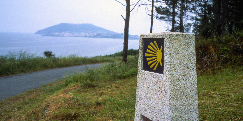
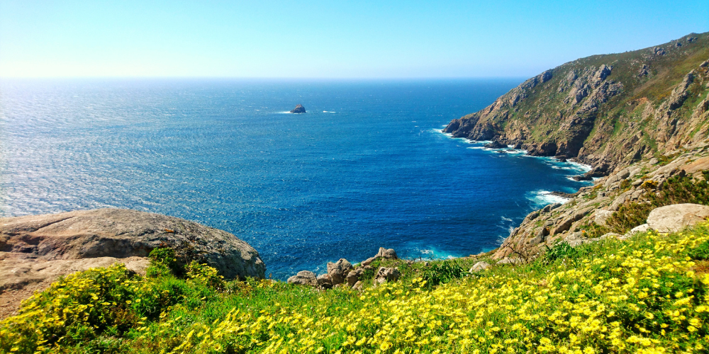
For centuries, many walkers continued west toward the Atlantic Ocean, following a path to a rugged coastal cape once believed to be the westernmost point of the known world. The Romans called this place Finis Terrae, meaning “the end of the earth.” Standing on the cliffs above the Atlantic today, it’s easy to understand why early travelers believed the land simply ended here.
This route, known as the Camino Finisterre, offers a quieter continuation of the Camino experience. Instead of crowded pilgrim routes and busy hostels, the trail winds through peaceful forests, farmland, and small Galician villages before reaching the dramatic coastline of northwestern Spain.
For many travelers, walking beyond the bustling streets of Santiago de Compostela and continuing on to the sea becomes one of the most meaningful parts of the journey. The quieter trail creates space for reflection, allowing pilgrims to consider the same questions travelers have carried along this route for centuries.
What Is the Camino Finisterre?
The Camino Finisterre begins at the popular Santiago de Compostela and stretches roughly 55 miles (90 kilometers) west to the seaside town of Finisterre. Many pilgrims also choose to continue north for another 18 miles (30 kilometers) to the fishing village of Muxía, extending the journey along the Atlantic coast.
Unlike the traditional Camino routes that lead toward Santiago, this path moves in the opposite direction, away from the cathedral and toward the sea.
The atmosphere along this route feels noticeably different. With the main pilgrimage destination now behind you, the trail becomes quieter and more reflective. Walkers pass through farmland, wooded paths, and historic villages where daily life moves at a slower pace.
Some travelers choose this route after completing the classic Camino de Santiago. Others walk it as their first pilgrimage, drawn by the symbolism of ending a journey by the ocean.
Camino Finisterre Stages (Day-by-Day Breakdown)
Most people complete the Camino Finisterre around a week. The time to finish just depends on how much you want to walk in a day, at what pace you go and the itinerary, including if you are adding on Muxía or not. Each stage reveals a slightly different side of Galicia’s landscape, gradually transitioning from inland countryside to coastal views.
Santiago de Compostela to Negreira
The journey begins in the historic streets of Santiago de Compostela. You’ll leave the city behind and head into quieter city outskirts. The landscape shifts into beautiful rolling hills, lush forests, and small villages home to many farmhouses.
Many pilgrims decide to spend their first night along the route in the town of Negreira.
-
Distance: 13 miles / 21 km
-
Elevation Gain and Loss: 1,470 feet gain / ~1,800 feet loss
-
Terrain: A mix of paved village roads, forest paths, and rural country lanes with gentle rolling hills.
-
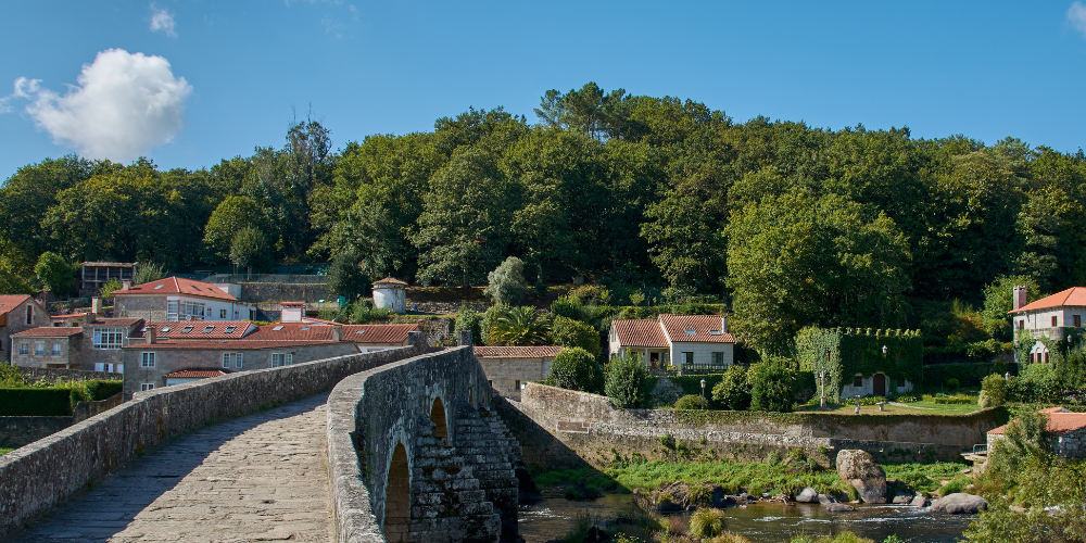
Major Highlight: Ponte Maceira, a beautifully preserved medieval village known for its arched stone bridge crossing the Tambre River.
Negreira to Olveiroa
The next stage of the route goes even deeper into the Galician countryside. Along this stretch, thriving farmland and pastures stretch across gentle rolling green hills. Pilgrims follow quiet rural roads and forest paths, passing small hamlets where the community relies heavily on agriculture. This section feels very peaceful and reflective.
The day typically ends in Olveiroa, a small village surrounded by green hills and traditional stone buildings.
-
Distance: 20 miles / 32 km (often shortened to be 12 miles with a transfer, Santa Marina, like on the AGC itinerary)
-
Elevation Gain and Loss: ~1,050 feet gain / ~ 850 feet loss
-
Terrain: Mostly rural roads with long rolling sections through farmland and forests.
-
Major Highlight: Expansive views across rural Galicia and the quiet agricultural landscapes that define this region.
Olveiroa to Cee
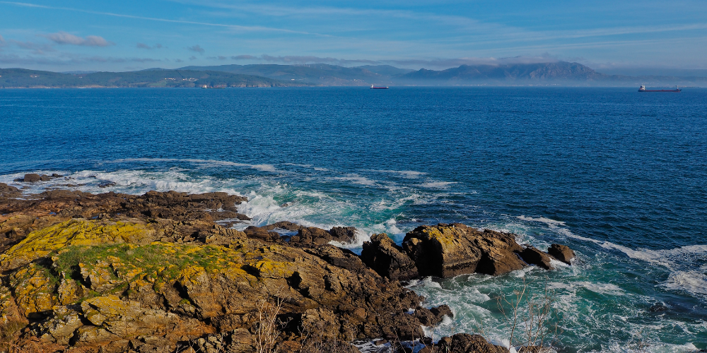
For many pilgrims, this stage brings one of the most emotional moments of the entire journey. After days of walking through inland countryside, the landscape begins to open up to see the Atlantic Ocean for the first time. Seeing the sea after days of walking west can feel surprisingly powerful.
Pilgrims often pause along the trail to take in the view before continuing toward the seaside town of Cee.
-
Distance: 12 miles / 19 km
-
Elevation Gain and Loss: ~330 feet gain / ~500 feet loss
-
Terrain: Rolling countryside with open farmland, forest sections, and gradual descents toward the coast.
-
Major Highlight: The first glimpse of the Atlantic Ocean is a powerful moment for many pilgrims nearing the end of their journey.
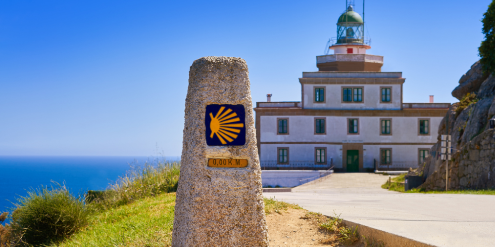
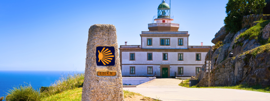
Cee to Finisterre
The trail at Cee continues toward the coast, offering continued glimpses of fishing harbors, beaches, and seaside villages. The end of this section brings pilgrims to the lighthouse at Cabo Fisterra, where the famous 0.00 kilometer marker symbolizes end of the Camino.
Traditionally, pilgrims burned their clothes or shoes at the cape as a ritual marking the end of their journey and the beginning of a new chapter.
-
Distance: 7.5–12 miles / 12–15 km (depending on route variation)
-
Elevation Gain and Loss: ~500 feet gain / ~500 feet loss
-
Terrain: Coastal paths, forest sections, and seaside roads leading toward the cape.
-
Major Highlight: Cabo Fisterra Lighthouse and the 0.00 km marker, marking the symbolic end of the Camino.

Finisterre to Muxía
Many walkers choose to continue beyond Finisterre to Muxía, adding one final coastal stretch to their pilgrimage. This section of the Camino winds along beaches, fishing villages, and dramatic Atlantic cliffs before reaching the Sanctuary of the Virgin of the Boat. According to local legend, the Virgin Mary arrived here in a stone boat to encourage Saint James in his mission. Today, the sanctuary remains one of the most meaningful sites along the Camino Finisterre.
-
Distance: 18 miles / 29 km (often broken up into two days like on the AGC itinerary)
-
Elevation Gain and Loss: ~1,000 feet gain / ~1,090 feet loss
-
Terrain: Coastal paths, village roads, and rolling terrain with views of the Atlantic.
-
Major Highlight: The Sanctuary of the Virgin of the Boat in Muxía along the Atlantic Ocean
What Makes This Camino Extension Unique
While the traditional Camino de Santiago focuses on reaching the cathedral in Santiago, the Camino Finisterre offers a different kind of experience filled with greater moments of peace, quiet, and reflection.
The trail passes through rural Galicia, where pilgrims encounter quiet farmland, centuries-old villages, and coastal landscapes shaped by the Atlantic Ocean. With fewer travelers on the route, the pace feels slower and more contemplative.
On our Santiago to the Sea: Camino Finisterre adventure, small groups of women walk this historic route together while staying in charming family-run hotels along the trail. Luggage transfers allow participants to walk with just a daypack, and experienced guides help bring the Camino's history and traditions to life.
The journey concludes in Muxía, where the group gathers for a farewell dinner overlooking the Atlantic, an opportunity to celebrate the miles walked and the friendships formed along the way.
